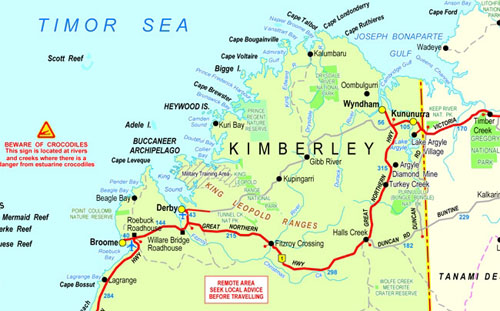
Kimberley Map
The Kimberley region of Western Australia is a wilderness ready to be explored, click the map below for more information.
For a higher-quality map of Western Australia. PDF format please visit our Western Australia Map page.

This ancient region, which covers nearly 423,000 square kilometers, has the lowest population density per square kilometer of any place on Earth.
Kimberley holidays in Western Australia’s North are complemented by the spectacular landscapes, gorges, and waterfalls that make up the heart of the region. On its coast, you’ll find some of the most beautiful beaches in the world. You’ll also discover untouched coral islands and rugged isles with an incredible variety of marine life.
The Kimberley region offers a wide range of experiences. Visit Kununurra or Derby – the eastern and Western gateways to Kimberley. Stop by the pioneering towns Wyndham Fitzroy Crossing, and Halls Creek.
There are wilderness adventures in all corners of the region. You could spend your Kimberley vacation in Western Australia’s Purnululu national park, which is home to the world-famous Bungle Bungles. You could also visit the stunning Mitchell River National Park or the beautiful Danggu Geike Gorge National Park .
Dimalurru National Park allows you to explore ancient caves. Walk through the stunning Bandilngan. Lake Argyle is a vast inland lake. Explore one of the largest meteorite-craters in the world at Wolfe Creek Crater National Park.
While Broome Cable Beach has been rated as one of the best beaches in the world, the Kimberley region also offers many other world-class attractions. You can snorkel with more than 650 different species of fish on a dive or snorkel tour at Rowley Shoals Marine Park. Kimberley cruises take you to the Buccaneer archipelago where you can see the incredible tidal movement at the Horizontal Fall. You can visit places that few people have ever been to.
Broome lies along the western coast, on the semi-arid edge of the canning basin. The population is approximately. Broome, with its 17,000 residents, is a well-known pearling port, tourist town and hub for the pastoral and resource industries.
Derby lies 200km north-east of Broome, with an estimated resident population of check that. Derby is located in Salt-Water Country and has the second-largest tidal movement in the world. It is also the gateway to Dampier Peninsula’s thousand islands.
Fitzroy Crossing lies on the Fitzroy River’s banks, about 2.500km north-east of Perth. The area has a variety of fertile soils, which are used for livestock and horticulture.
Halls Creek is a combination of desert and pastoral grazing lands with unique natural attractions like the World Heritage Listed Purnululu Park and Wolf Creek Crater. This area has a thriving tourism industry.
Kununurra is located just 37km from the Northern Territory border. It’s a hub of tourism, mining, and agriculture, including the Purnululu national park – Bungle Bungle ranges, Ord River Irrigation Project, and the massive artificial Lake Argyle.
Wyndham was founded in 1886 and is situated at the point where five rivers enter the Cambridge Gulf. It was the main point of entry for the gold rush. Its port serves the agricultural and pastoral industries in the region.
